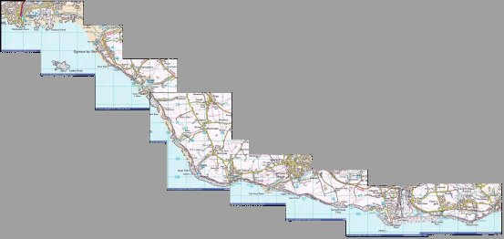
To view detailed OS maps of the area, on
which 1 square = 1 km, click on one of the
regions; (each image is about 200 kB.)
which 1 square = 1 km, click on one of the
regions; (each image is about 200 kB.)
I. CAVRA |
II. BELA |
III. First Aid |
IV. College |
For a roadmap of the area, click here.
( 1 square = 10 km, 78 kB. )
The table below lists, from East to West, the access points, landmarks and other special features along our part of the coast which all members of CG-Service should be familiar with.
The path on the cliff-top along most of our part of the coast is maintained by an organisation called the ''Heritage Coast''. Their members know the area extremely well and have always been very cooperative. A key for all the Heritage Coast gates should be in each landrover.
| Legend: | access is possible | get cut off by tide early | "unofficial place names" |
| E A S T | ||
| Font-y-gary Caravan Park | ||
| Leys Bay | ||
| Breaksea Point | by the Power Station | water inlet for the Power Station |
| Gileston Beach, in Limpert Bay | ||
| Boverton Beach, in Summerhouse Bay (= Penry Bay) |
access through Camp or down the footpath from ... | |
| Summerhouse Point | Heritage Coast gate on access road, where there is the old ... | |
| CG-Lookout | disused; access via Boverton Mill Farm | |
| Stout Point | ||
| New Way Stair | a steep scramble; access via Rosedew Farm, then along field; (N.B.: the farmer does not like us to drive across his land) | |
| Pigeon Point | ||
| Llantwit Major Beach (= Col-huw Point) | Lifeguard Station | |
| Dimhole | a drop in the cliff, a steep scramble | |
| Tresilian Bay | access along the private road, through gardens | |
| Reynard's Cave | ||
| Stradling Steps | fairly steep steps | |
| ''Demo Cliff East/ West'' | ||
| St. Donats Bay | RNLI Station, slipway | |
| St. Donats Point | ||
| Lighthouses | N.B.: Nash Point is on the other side of ... | |
| Cwm Marcross (= Nash Cwm) | ''cwm'' is just the Welsh word for a valley | |
| Nash Point | Nash Sands stretch West; the other side of Nash Passage marked by East Nash Buoy | |
| Cwm Nash (= Monknash Cwm) | access along foot path -- parking/ rendezvous point at New Mill Farm | |
| Whitmore Stairs | an old rock-fall, by now a very steep scramble | |
| Wick Beach | ||
| Cwm Bach | iron ladder -- the top now difficult to access by vehicle | |
| Cwm Mawr | waterfall; not an access point | |
| Dunraven Steps, in Temple Bay | comfortable to walk; Heritage Coast gate on the road to the top of the stairs (key in the vehicles) | |
| Witches Point | popular for fishing from | |
| Southerndown Beach (= Dunraven Bay) | ||
| Little West Hotel | an ILB landmark; now an old people's home | |
| ''Big Ogmore'' | has been popular for climbing, but very loose rock | |
| Castle Rock | in the sea | |
| West Farm | by the road | |
| the Deeps | caves at sealevel; used by fishermen for getting bait | |
| ''Little Ogmore'' | ||
| ''Ogmore Crack'' | easy access to the waterline everywhere to the West of here | |
| Brig-y-don Hotel | an ILB-landmark; can drive down to the cliff top from here | |
| Ogmore beach | Heritage Coast gate at East end of carpark | Tusker Rock, about 2 km out at sea, covered at high water |
| Ogmore Lifeguard Station, or Pen-y-bont SLSA | ||
| the Flats | a large area of gravel covered at high water; dangerous tidal currents | |
| bank of the Ogmore River | with the ruins of the old castle 2 km upstream | |
| W E S T | ||
Something to think about: if the earth turns underneath the moon once every 24 hours, and high tide is due to the moon attracting the water in the sea, why are there two high tides per day, i.e why is the water high on the opposite side of the earth from the moon as well?When the sun and the moon are 'pulling in the same direction', High Water is especially high and Low Water especially low; in practice these spring-tides occur two days after a full or a new moon, i.e. about every 14 days. The opposite are neap-tides: half-way between two spring tides, High Water is less high and Low Water less low. The highest spring tides occur in spring and in autumn, when the earth is closest to the sun.
It is important to keep in mind how quickly the water level changes at certain times between High and Low Water: fastest when it is half-way up or down. The Rule of Twelfths states that in the approximately six hours between Low Water and the next High Water (or between High Water and the next Low Water), the water rises (or falls) by 1/12 of the total height difference in the first hour, by 2/12 in the second hour, then by 3/12, 3/12, 2/12, and 1/12 in the remaining hours.
I used to have a table of the times of High Water at Barry on this website, for use at the College. The information came from WXTide32, a convenient Windows port of a Linux program. But having been informed by Miss T J Wenham, the Assistant Copyright Compliance Officer at the UK Hydrographic Office, that using the harmonic constants required by WXTide32 infringes Crown copyright, I have had to remove this service from my page.2nd-year students in CAVRA should in general know the approximate time of the next High Water, especially of course when they are on call-out duty, and perhaps also whether it is spring- or neap-tides. Note that tides are also especially high when the wind is blowing from the West.